Ellipsoidal Cube Maps for Accurate Rendering of Planetary-Scale Terrain Data
M. Lambers and A. Kolb, Ellipsoidal Cube Maps for Accurate Rendering of Planetary-Scale Terrain Data,
Proc. Pacific Graphics (Short Papers), Sep. 2012.
(PDF download. The definitive version is available at http://diglib.eg.org/ in
the Pacific Graphics 2012 short paper section.)
Contact: Martin Lambers.
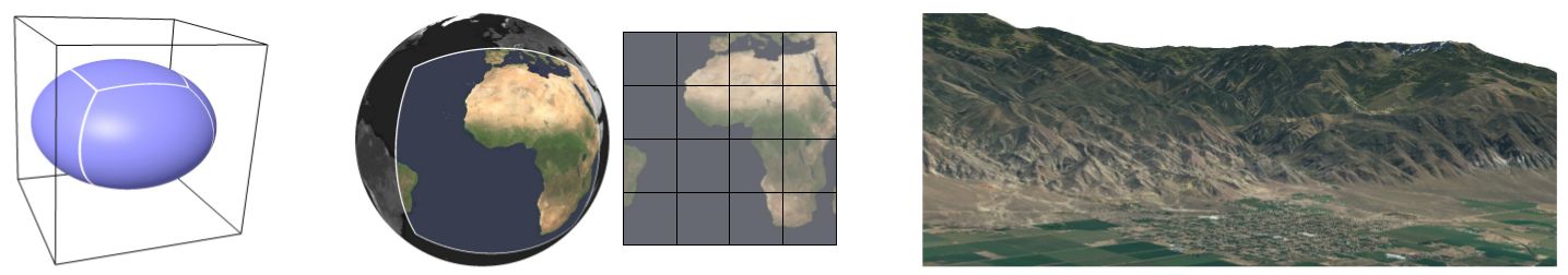
Using an ellipsoidal planet model circumscribed by a cube (left) combined with a carefully chosen map projection (middle)
and a precision-aware organization of geometry computations results in improved accuracy for rendering of planetary-scale, high-resolution
terrain data (right).
Overview
Ellipsoidal Cube Maps (ECMs) store planetary-scale terrain data in quadtree hierarchies.
ECMs have the following advantages:
- Data is correctly interpreted relative to the reference ellipsoid, not relative to an oversimplified spherical planet model.
- The map projection is equal-area and at the same time limits angle distortions. It provides nearly uniform sampling quality
across the complete planet surface, without degradations in border regions such as the poles.
- Numerical accuracy limitations are properly addressed. Rendering without artefacts is possible with single-precision graphics pipelines.
This site provides demo software for ECMs, consisting of three parts:
libecmdb, which implements the basic model and projection, ecmdb,
which builds ECM databases from remote sensing data, and ecmview, which
renders ECM databases interactively.
This software is licensed under the terms of the GNU GPL version 3 or later.
This software was written for current Linux systems. Porting it to other systems should be straightforward, but was not done yet.
To help you get started, the script build-ecm.sh
downloads the latest version of the ECM software, builds it, and installs it
into a directory of your choice. Additionally, the script creates two small
example data bases. The script was tested on Debian and Ubuntu, but should
work on all recent Linux systems.
News
2012-11-12:
Version 0.7.0 of all packages is released. This version adds support for SAR amplitude images, including
interactive despeckling and dynamic range reduction. The relevant methods are described in the following papers:
- M. Lambers, H. Nies, A. Kolb, Interactive Dynamic Range Reduction for SAR Images, Geoscience and Remote Sensing Letters,
5(3), 2008, pages 507-511
- M. Lambers, A. Kolb, Adaptive Dynamic Range Reduction for SAR Images, Proc. 7th European Conference on Synthetic Aperture
Radar (EUSAR), 3, 2008, pages 371-374
- M. Lambers, A. Kolb, H. Nies, M. Kalkuhl, GPU-based Framework for Interactive Visualization of SAR Data,
Proc. Int. IEEE Geoscience and Remote Sensing Symposium (IGARSS), 2007, pages 4076-4079
libecmdb
This library implements the basic data structure and the map projection.
Source code repository: https://git.marlam.de/git/libecmdb.git.
Web frontend: https://git.marlam.de/gitweb/?p=libecmdb.git.
Note: the version for the Pacific Graphics 2012 paper was libecmdb-0.6.2.
Requirements:
ecmdb
This tool builds ECM databases from elevation models, orthophotos, or
other remote sensing data readable by GDAL.
Source code repository: https://git.marlam.de/git/ecmdb.git.
Web frontend: https://git.marlam.de/gitweb/?p=ecmdb.git.
Note: the version for the Pacific Graphics 2012 paper was ecmdb-0.6.2.
The documentation includes links to freely available data sets.
Requirements:
ecmview
This program renders planetary terrain data from ECM databases.
Please note that ecmview is a research prototype and not a polished end user product.
It is neither a fully-featured planet viewer nor a performance-optimized terrain renderer.
It is simply a demo program for ECMs. Nevertheless, it has some interesting features:
- Access to ECM databases via file system, HTTP, FTP, and other methods.
- Asynchronous caching using the disk, main memory, and graphics memory.
- Combination of different elevation models and texture data sets on the GPU
at rendering time, with interactively adjustable blending weights.
- Interactively adjustable processing of terrain data on the GPU at rendering
time, e.g. scaling of elevation data, color adjustment of texture data, or
generation of color ramps and isolines from elevation.
- Support for render clusters (distributed / multi-GPU), e.g. for Virtual Reality installations.
This software is targeted at powerful graphics hardware. It was written and tested
with a NVIDIA GTX480 GPU. It also runs on less powerful hardware (e.g. NVIDIA
8800GTX or Intel Core-i7 integrated graphics), but don't expect interactive
frame rates at full detail levels.
Examples:
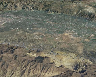
- An area in Utah. The elevation data is combined from data sets with different ground resolution at rendering time.
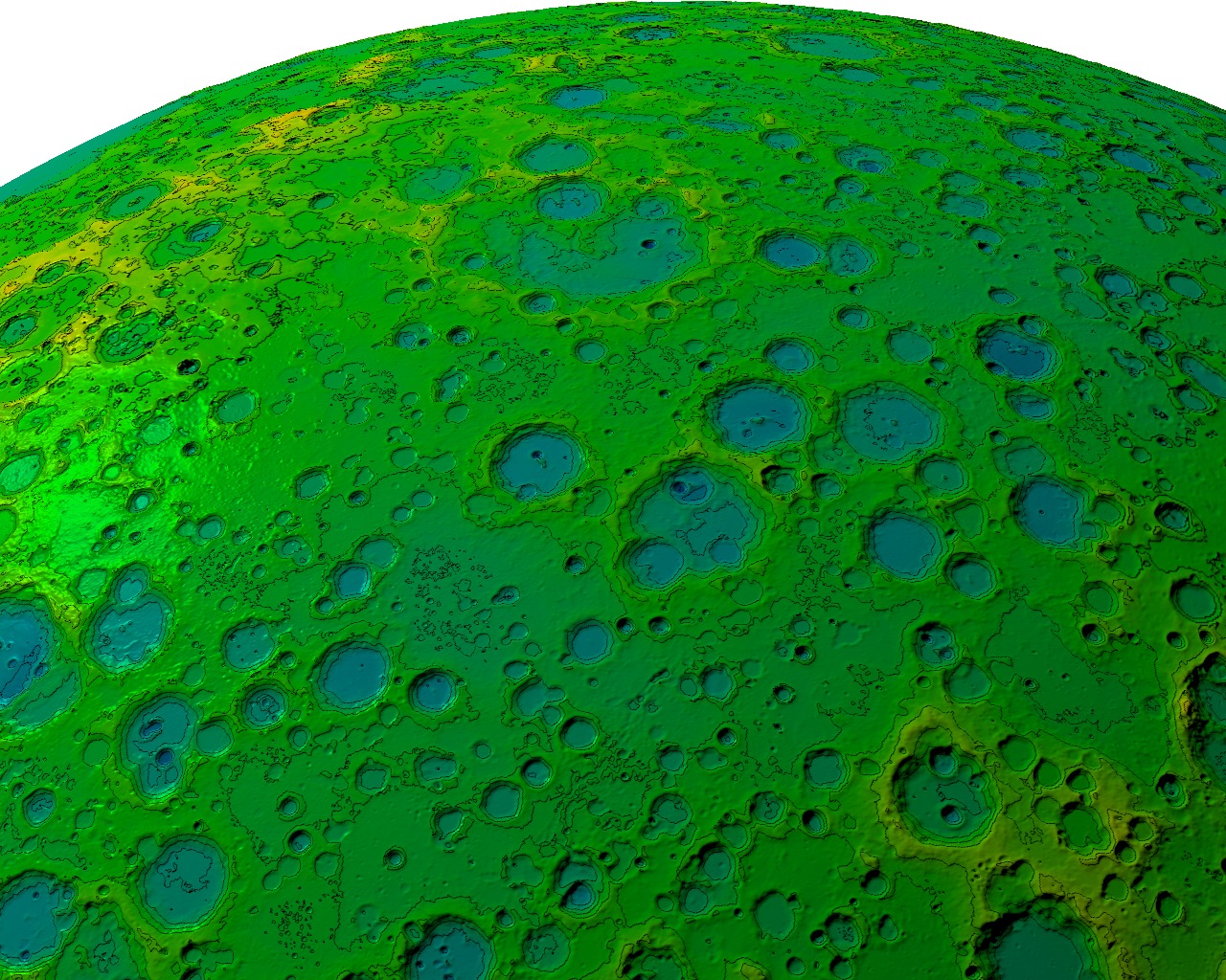
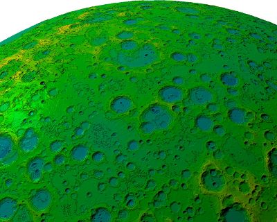
- Elevation data for the Moon derived from LROC images. Per-pixel lighting is applied. The color ramp
texture, including isolines, is computed dynamically from the elevation data during rendering.
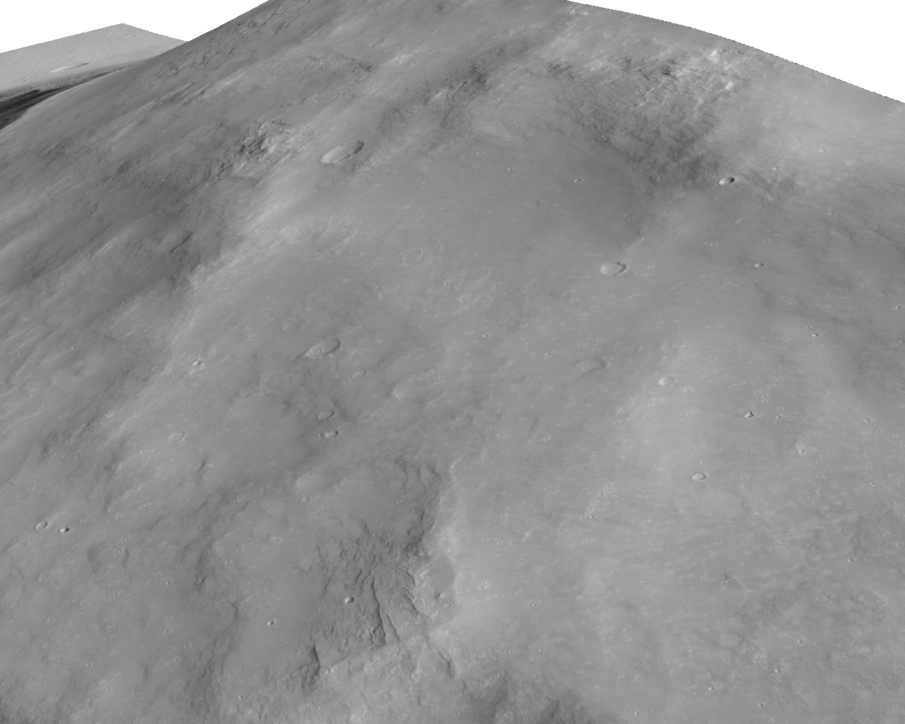
- A HiRISE image of Mars overlayed over elevation data from the Mars Orbiter Laser Altimeter.

Source code repository: https://git.marlam.de/git/ecmview.git.
Web frontend: https://git.marlam.de/gitweb/?p=ecmview.git.
Note: the version for the Pacific Graphics 2012 paper was ecmview-0.6.2.
Documentation.
Requirements: